A Hovercraft trip from Weston-S-Mare to Langford Grounds near Clevedon. ... by Peter Stanley
This event helped to celebrate Sir Christopher Cockerell's fifty years since he had invented the hovercraft (1959-2009).
Ross Floyd and I, recently met up after nearly 45 years both working upon separate hovercraft projects. He and I discussed our passion for hovercraft. He was interested in doing a longish trip using his offshore Cruising Hovercraft along the Severn Estuary. So with very little contemplation I said it sounded a very exciting adventure. The weather was set fair. When we reached the launch point upon the south western end of Weston -S-Mare beach the wind was blowing from the west. Our destination was to be Langford Grounds near Clevedon. This was linked in with a search for possible Luftwaffe aircraft which were marked upon the sea charts. Ross also loves aircraft and he had plotted the location of three crash sites upon the sea chart. Ross had also seen that there were two old rusty blockships marked so these were also logged into the GPS.
The main purpose of the trip was to thoroughly test out his craft "Britannia" as although it had done numerous engine runs on both land and water at the Marine lake Clevedon it had not been out for a really long run with salty water, mud and sand combined.
We loaded up all the kit and there was quite a lot of it! We set off for Weston S mare. The journey was noisily interrupted when we were overtaken by a coastguard vehicle on a shout to rescue someone off Weston.
We arrived at the southern end of the beach at Uphill opposite to Brean Down. They have now cordoned off this area so that vehicles cannot go beyond a certain point without official permission.(North Somerset Council and the Beach Rangers). Thankfully all was well with the red tape and we were duly met by two Beach Rangers who already had been briefed about our trip.
After unloading "Britannia" a most suitable name for his craft. Ross warmed up of the engines. Britannia has a Briggs and Stratton 35hp thrust engine and an 8 hp lift engine). A fellow offshore hovercraft enthusiast of Ross's was supposed to be meeting us to shadow the trip and help out in any emergency. Ian Brooks and his wife had phoned to say they were stuck in heavy M5 traffic so whilst we waited for them to arrive we headed off down the beach eventually reaching the sea some 2 miles from the trailer. Always very useful for the crew to keep an eye out for obstacles which appear in the path of the craft because the pilot may not always notice them due to mud and water on their goggles, especially when one is travelling sideways at approximately 23 knots.
After reaching the sea we headed for a small muddy beach on the southern edge of Birnbeck Island. It was only my third time out to this part of the Severn Estuary. I do recollect one trip out on the paddle steamer Waverley in the 1960's and a trip in Clevedon Bay in 1971 with the sailing club as a radio operator for their regatta. Apart from that I had not ventured so far from the beach at Weston!

"Britannia" was exceptionally controllable and Ross was really enjoying the experience. Only shallow waves in a depth of about half a metre. The tide was still going out as it was the equinox. The lowest tide of the year on the 22nd August 2009. The same day had the highest tide causing the Severn Bore further up the river. We eventually reached Birnbeck Island and beached the craft on a very small patch of mud, which did not have skirt ripping rocks and jagged protuberances. We radioed Ian who had managed to get through the traffic. He was using his American designed craft with a three bladed propeller, it looked more like an Everglades Air Boat. It was an Impressive sight as we departed Birnbeck Island and met him halfway back to the launch site on Uphill Sands. A brief wave, thumbs up and we were off round the headland towards Sand Bay. We kept well away from the edge of the peninsula as we did not know for certain what was near the surface. The passage across Sand Bay was very exciting as we were travelling at around 21 knots. The wind was behind us for most of the journey across the bay. A few more waves were encountered as we stopped for a look around on the next headland SW of St Thomas's Head. The landing area was more suited to Ians craft and Ross and I did not really stay beached for long. A strong push off with the oar helped as there was no real turning area. Hovercraft do not have reverse gear or thrust and you often have to physically man handle them around if there is no space to slew them about. We then headed for our true destination of Langford Grounds SW of Clevedon. I was using the GPS and the visuals of the old sunken vessels which were part of our itinerary. On the outbound trip we went inside of the sand bank (really treacherous mud and quicksand combined) we could see miles of mud bank but as we approached it we could see how difficult traversing it was to become on the return journey *see photo of the undulating nature of the bank. We headed straight for HMS Staghound and carefully beached the crafts. Ian had warned us about the quicksand and deep mud. I used an oar to help prod the ground in front of me as we successfully clambered out onto the mud bank and began looking at the old vessel ( see photos of the vessel). Amazing sight of the old steam boiler and superstructure of the vessel.
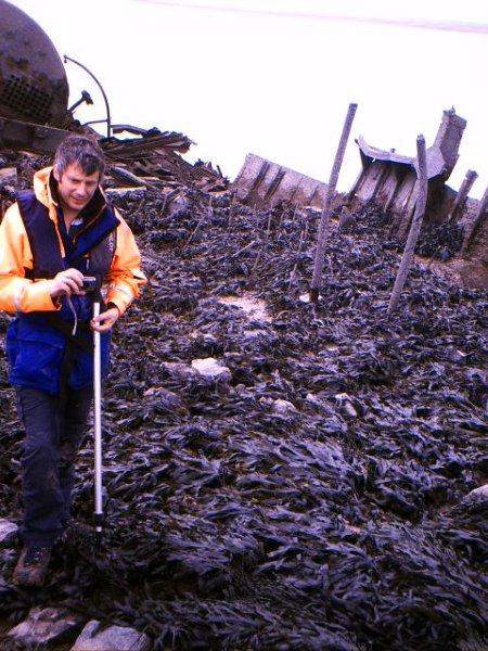
The vessels were old 19th Century warships which were to be used as block ships for D Day / the Allied invasion of Normandy, but one was bombed by the Germans and had to be beached before it sank whilst sailing down the Bristol Channel. The weather in 1944 was so rough that D Day was postponed for 24 hours and this may have contributed to demise of these block ships. Block ships were old vessels which were filled with ballast and were to be deliberately beached in Normandy so that they would be used as breakwaters for the Landing craft. They sheltered the LCT (Landing Craft Tank) from waves and swell. Unfortunately these ones took no part but at least are a monument to what happened in those dark days of WW2.

After some good photo opportunities we got back on board our crafts and began the GPS search for the location of the crashed Heinkel and Dornier bombers. Unfortunately we only found one of them. The Heinkel was not seen but a correct GPS location was shown. The mud was becoming a problem as I could hardly read the GPS screen. One of a few mods for next time will be a dry area for the GPS, out of the mud and dirty seawater. We then headed for the Dornier site but as can be seen from the GPS track we must have hovered over it without seeing any tell tale signs. These are war graves as one or more Luftwaffe crew did not survive their crash landings so one does not interfere with them. They are to be respected at all times. No souvenir hunting, photos perhaps.

We continued the return journey from Langford Grounds by trying to navigate across a part of the sand bank. Ross had been warned to be very careful about collapsing gullies as we crossed a part of the undulating sandbank. There were huge gullies and also banks which caused Britannia some problems. We had to get out and push three times to unbalance the keel line of the craft. Ross even found one area of sand bank turning very quickly into a tin gloupy quicksand. The angled slopes of the gullies were such that extreme caution had to be taken (see photo). Ian's comments about collapsing gullies were heeded as he had said how craft can turn over and become difficult to get back upright. We passed over this area safely and Ross decided to head out to the seaward side of the sand bank which had turned out to be wider and longer than we had anticipated. For interest we had checked our fuel tank and it had only used around 1.5 gallons (7 litres) for the outbound trip. This was good going as the engine was running around 3100 rpm and giving us around 20 knots.
The circumnavigation of the sand bank was interrupted by two more forays into the unknown. First attempt at searching for the light aircraft crash site was abandoned as the sand was too wet and unstable. The second shot was better as Ross decided to hover up one of the small rivulets which was still draining large amounts of water to the outgoing tidal stream. It was very exciting manoeuvring up a narrow stream in between the undulating sand banks.

After some searching visually and checking the muddy screen of the GPS we headed for home. This was equally exciting as the wind was against us and the waves had built up as we headed for the promontory at Sand Bay. At one point, I advised Ross to try a 45 degree angle of attack into the oncoming wind. The combination of waves and wind caused the hovercraft her to slow down to about 12 knots. Once we had traversed the shallow waves the speed built up once more (back up to around 19 knots). Ross commented that he had felt some plough-in developing, but we trimmed the weight distribution and no further problems were reported. Plugh in occurs when the bow of the hovercraft literally goes under the water and the craft does a somersault. Rather embarrassing at speed! We kept away from the headland of Sand Bay on the return trip.
We did not want any adverse reports as North Somerset Council had been most welcoming for this special trip from Weston-Super-Mare. We crossed Sand Bay without any problems and then just the last headland before a real flourishing run back to the launch site. Interestingly as we approached the beach both Ross and I noticed what appeared to be seaweed. Always ere on the side of caution.... luckily we did so, as it was in fact a ridge of very sharp rocks making for a rapid slow down and a new route back to the sand of Weston. We had travelled over 25 nautical miles in company with Ian and his wife. We had gone to places which normally do not have visitors and I was privileged to be allowed to come along upon this adventure with Ross and Ian. This type of Craft made by Bill Baker Vehicles(BBV) is really suited to offshore cruising and navigating the more inaccessible areas.

The trip was very well planned by Ross and we all had a very exciting afternoon.

The biggest problem we suffered were goggles and GPS screen getting covered in mud.
This was a great way of celebrating the 50 years since the hovercraft had been invented by Sir Christopher Cockerell (1959)
Story written by
Peter Stanley and
Ross Floyd
LS 1965-66
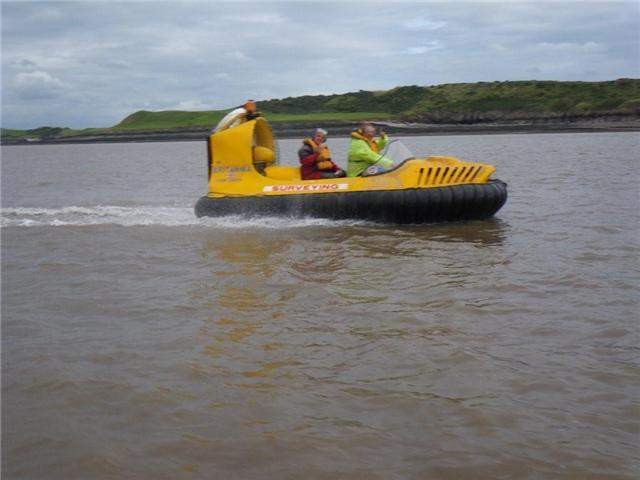 "Britannia"off the coast of North Somerset near Sand Bay travelling west, pilot Ross Floyd and Peter Stanley (Navigator and goggles cleaner...)
22nd August 2009
Photo Ian Brooks